First Alert Forecast: Strong trade wind weather all weekend
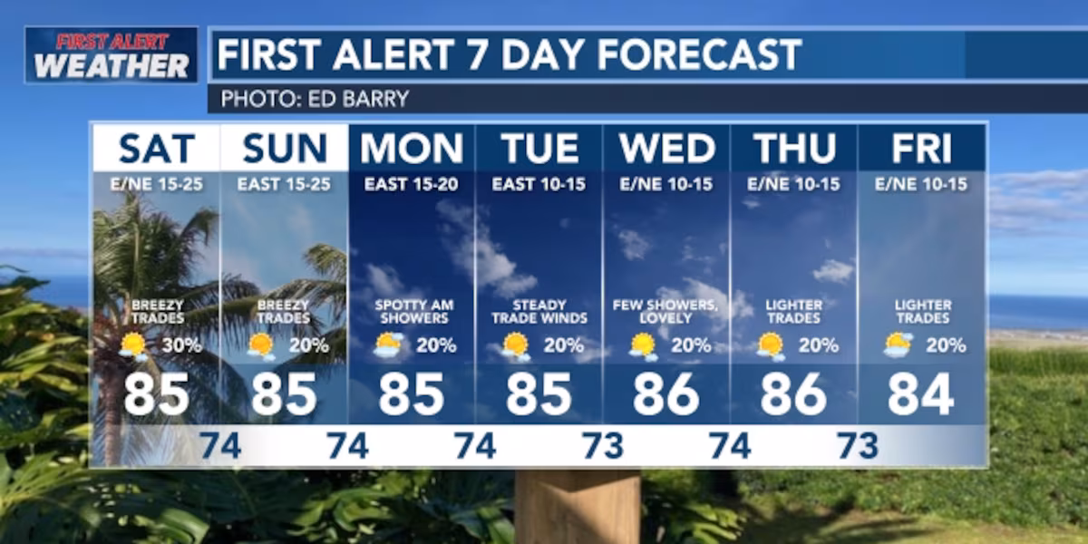
HONOLULU (HawaiiNewsNow) – The wind will stay breezy this weekend, but will calm down by the middle of next week.
Read more What’s Cooking: Aloha Tequila Fest supports Aloha Cancer Project
You’ll see some sunshine with rain showers scattered around, especially on the windward side and inland areas. By next weekend, the wind might get light enough that we’ll see a shift in the wind pattern based on how warm the land and ocean get during the day.
View the latest weather conditions here.
Weather models all agree that strong winds will keep blowing from the east-northeast through the weekend. Expect lots of sunshine, mixed with those clouds and showers. Moisture moving in from upstream will bring scattered showers, with more rain expected tonight. Right now, there are low clouds and scattered showers across the islands, mainly hitting the windward (wet) side and inland areas
A strong high-pressure system far north of the islands will stick around through the first half of next week, keeping the winds steady and breezy. Showers will mainly happen on the windward and inland areas, especially overnight and early in the morning. By the second half of next week, a weather system passing north of the islands could weaken the winds.
For this weekend, box jellyfish will be in the shorelines of the south side; so check with lifeguards before going into the water.
Read more Marine mammal death prompts closure of Hanauma Bay beach
The ocean waves coming from the south will keep getting smaller through Sunday, but there’s uncertainty about what waves will arrive Sunday night and Monday. As these waves fade late Sunday, the first signs of new waves from the south should show up. The new swell is heading mostly east of Hawaii, so it’s unclear how much energy will reach us locally, but south-facing beaches could see waves around or slightly higher than normal June levels from Monday through Wednesday. A smaller set of waves from the south-southwest is expected Thursday and Friday, with bigger waves from that direction arriving next weekend.
On the north side of the islands, small waves will fade tonight, and tiny waves from the west-northwest will show up early next week. On the east-facing shores, rough waves will stay around normal through Sunday, then gradually calm down through the middle of next week as the wind weakens.
Download the HNN Weather app from the Apple App Store or Google Play for the latest updates from your First Alert Weather Team: chief meteorologist Jennifer Robbins, meteorologist Drew Davis, and weather anchors Guy Hagi, Ben Gutierrez, and Billy V.
Read more Hanapepe man sought in gunshot investigation apprehended


Post Comment