First Alert Forecast: Breezy, strong trade wind weather next 7 days
HONOLULU (HawaiiNewsNow) – Multiple areas of high pressure are hanging out North of the Hawaiian Islands and will stick around for at least the next week. Also there’s a dip in the jet stream (fast-moving air high up in the atmosphere) that’s parked over Hawaii. This is basically keeping the weather pattern locked in place.
Read more First Alert Forecast: Breezy trades to blow through the holiday weekend
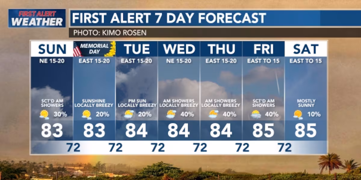
This means we will see consistent moderate to locally strong easterly trade winds and showers, but not everyone will get in on the rain activity. Only in certain spots, mostly windward and mauka sections of the islands; mostly during overnight hours and early mornings. The leeward sides will stay mostly dry. We’re expecting this pattern to be locked in for at least the next 7 days — so expect the same type of weather to repeat.
View the latest weather conditions here.
Instead of the typical dry summer, Hawaii is about to get more rain than usual. There’s a “trough” (a dip in the upper atmosphere) that’s keeping moisture and instability in the forecast. Think of it like someone left the fridge door open — the cold air is mixing with warm air and creating unsettled conditions.
Brief, passing showers — rain bands will move through quickly, especially over the windward and mauka areas. Rain amounts will be light because the showers move fast.
Next Weekend: Possible increase in rain — there’s a hint that a weather system (remnants of a front from the Pacific) could bring more clouds and showers statewide. Still not heavy rain, but more activity than usual. BUT its at least 7 days out which means lots could change between now and then.
Read more Suspect dead after opening fire near White House security checkpoint, Secret Service says
⚠️Small Craft Advisory: Through tonight, then continues for windier waters Monday through much of the week — stay out of the water if you’re not experienced.
Surf Report: South-facing shores: Waves dropping early week, then a fresh south swell arrives Tuesday and builds to near-average by mid-week. Big swell coming Friday-next weekend (20+ foot waves expected) — this could be great for experienced surfers!
North & West-facing shores: Small waves today, lowering Monday. Long-period swells arriving Tuesday and building by Wednesday — above-average surf expected.
East-facing shores: Rough through Tuesday, then gradually improving mid-week.
Download the HNN Weather app from the Apple App Store or Google Play for the latest updates from your First Alert Weather Team: chief meteorologist Jennifer Robbins, meteorologist Drew Davis, and weather anchors Guy Hagi, Ben Gutierrez, and Billy V.
Read more Violent shaking from 6.0 earthquake damages Hawaii Island homes, rattles residents


Post Comment