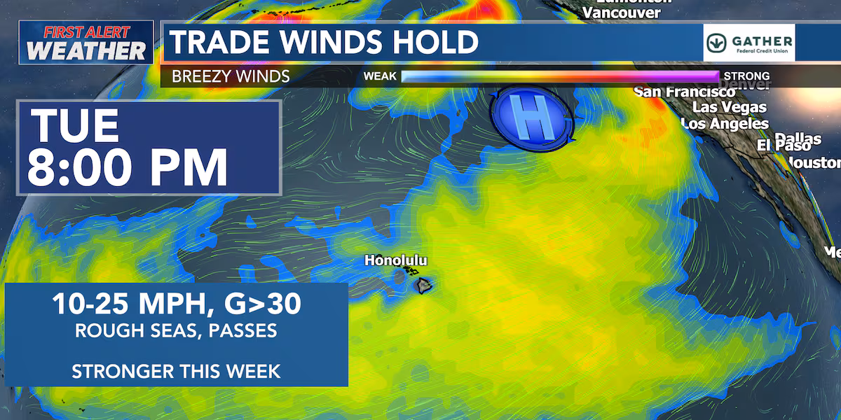
First Alert Forecast: Heavy pockets of spotty rain into Tuesday then make sure to hold on– gusty trades are coming our way
HONOLULU (HawaiiNewsNow) – Today and tomorrow some pockets of heavy rain. An unsettled trade wind pattern will continue across Hawaiʻi through Tuesday night, bringing humid conditions and periods of showers, especially for windward and mauka communities. Some showers may become briefly heavy at times, with localized downpours possible before conditions gradually improve later in the week.
Read more Buyers beware: Copyright concerns on the rise for Hawaii artists
Radar earlier this afternoon showed showers developing over many windward areas, along with the Kona districts of the Big Island. A few of these showers produced moderate to heavy rain, prompting flood advisories for portions of Kauaʻi and the Big Island. Most shower activity is expected to ease around sunset, although overnight and early morning showers will continue for typical windward locations.
Trade winds have generally been blowing between 10 and 20 mph, with gusts reaching 20 to 30 mph. The air remains fairly humid for now, but drier air is expected to begin arriving Tuesday night and continue through Wednesday night. Once this drier air settles in, Hawaiʻi should see more comfortable conditions with lower humidity, fewer heavy showers, and cooler nights in sheltered areas. From Wednesday into early next week, high pressure north of the islands will strengthen and bring a more stable weather pattern.
Trade winds will increase to moderate and breezy levels statewide, while rainfall becomes more focused over windward and mountain areas. Leeward communities should see sunnier and drier conditions overall.
Read more Holy Ghost Feast celebrates 133 years on Maui
Marine conditions will gradually become rougher later this week as strengthening trade winds build seas across local waters. A Small Craft Advisory remains in effect for the typically windier waters around Maui County and the Big Island through Wednesday morning, and additional marine advisories may be needed later this week. East shore surf is expected to rise by Thursday and Friday as stronger trades increase wave energy, while south shore surf should remain near seasonal averages.
Minor coastal over wash may continue during peak high tides in low-lying shoreline areas.
View the latest weather conditions here.
Download the HNN Weather app from the Apple App Store or Google Play for the latest updates from your First Alert Weather Team: chief meteorologist Jennifer Robbins, meteorologist Drew Davis, and weather anchors Guy Hagi, Ben Gutierrez, and Billy V.
Read more Murder trial begins for Larry Millete in death of Radford grad Maya Millete


Post Comment