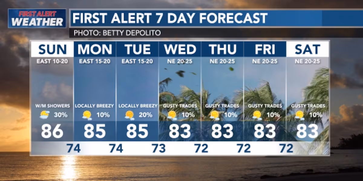
First Alert Forecast: WET trade wind flow and still slightly unstable conditions
HONOLULU (HawaiiNewsNow) – The system that brought us the rain on Friday and Saturday is moving off to the east away from the Hawaiian Islands, but slow at best; so conditions are improving slowly as we get trade wind weather back starting later Monday into Tuesday.
Read more Police open negligent homicide investigation following hit-and-run
View the latest weather conditions here.
What Happened: Heavy rain on the windward (eastern) side stopped overnight. Some areas got 1-2 inches of rain before midnight. The leeward (western) side stayed mostly dry because winds were weak.
Next Couple Days:
Late Tuesday/Wednesday: Conditions improve—stronger trade winds move in and things dry out.
Weekend Waves:
North Shore will see small waves today through tonight, then declining with another small swell expected Tuesday. West side holds steady; town spots will see small waves for the next several days. East sides will be rough and choppy conditions for the next several days due to the winds picking up.
Read more Hawaiian Electric continues power restoration efforts after lightning outages
Maka’ala (Be cautious): Peak monthly high tides combined with water levels that will be running higher than predicted will lead to minor flooding along the shoreline and in low-lying coastal areas. Coastal flooding is possible around the daily peak tides, which will occur today (Sunday) around 5:00pm this evening with a high tide of 2.5 feet.
Download the HNN Weather app from the Apple App Store or Google Play for the latest updates from your First Alert Weather Team: chief meteorologist Jennifer Robbins, meteorologist Drew Davis, and weather anchors Guy Hagi, Ben Gutierrez, and Billy V.
Read more City leaders celebrate opening of Makiki Banyan affordable housing project


Post Comment