First Alert Forecast: Tracking a large south swell plus slower winds for a few days
HONOLULU (HawaiiNewsNow) – A powerful south-southwest swell continues to impact our islands today, with a High Surf Warning remaining in effect through early Tuesday morning for south-facing shores. Surf remains well above normal, and the combination of large waves and King Tides could lead to significant wave run-up and minor coastal flooding in low-lying areas, especially around the late afternoon and early evening high tides.
Read more Chinese millionaire faces deportation despite $100M Hawaii real estate investment
If you’re heading to the beach, use extra caution near the shoreline, harbor entrances, and exposed coastal roads. Surf will gradually ease Tuesday and Wednesday, but another pulse of south swell is expected to arrive late Wednesday into Thursday, bringing another boost to south shore surf.
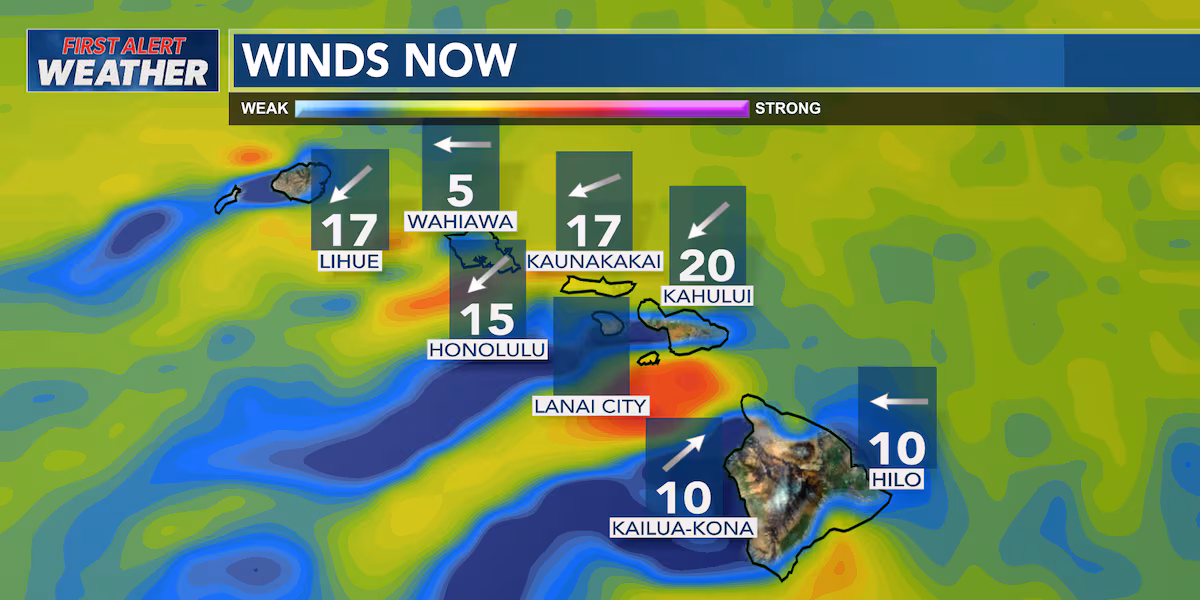
As for the weather, moderate trade winds will continue today, bringing a few passing showers to windward and mauka communities this morning. A drier and more stable air mass is moving in, so shower coverage will decrease through the day, allowing for more sunshine statewide this afternoon.
Rainfall overnight was generally light, with only modest accumulations across windward areas.
Tuesday will bring much of the same, although trade winds will ease slightly. Most showers will remain focused along windward slopes, while leeward areas stay mostly dry with pleasant early-summer conditions.
By Wednesday and Thursday, winds will become light enough for sea breezes to develop during the day and land breezes overnight. That means clouds and a few afternoon showers will be more likely over island interiors and mountain areas rather than along the typical windward locations.
Read more High surf warning in effect as powerful south swell hits Hawaii
We are also tracking a pocket of deeper moisture moving north from the southeast during the second half of the week.
The Big Island has the highest chance of seeing increased shower activity, particularly along eastern districts, with some of that moisture potentially reaching Maui County and portions of Oahu later in the week.
Looking ahead to the weekend, a more typical June pattern appears likely to return. Trade winds should gradually strengthen again, pushing showers back toward windward and mauka areas while leeward communities enjoy sunnier and drier conditions.
Overall, no major weather systems or widespread impacts are expected heading into Father’s Day weekend.
View the latest weather conditions here.
Download the HNN Weather app from the Apple App Store or Google Play for the latest updates from your First Alert Weather Team: chief meteorologist Jennifer Robbins, meteorologist Drew Davis, and weather anchors Guy Hagi, Ben Gutierrez, and Billy V.
Read more Police shut down alleged illegal gambling operation in Waianae


Post Comment