First Alert Forecast: Big Surf Approaching South Facing Shores
HONOLULU (HawaiiNewsNow) – Caution: Waves are starting to grow in size starting this afternoon to eventually dangerous life-threatening warning size waves. More details below.
Read more Maui seeks input on transportation projects, including $200M Lahaina Bypass
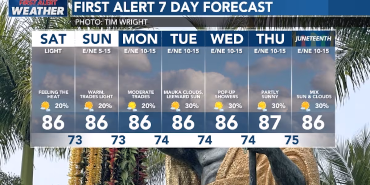
Trade winds will be lighter today, then start picking up again tomorrow. This will mean clear midmorning into the midday. Possibility of leeward afternoon showers with the lighter winds. This should mean a nice cool night with clear skies. It also means the possibility of fog and haze drifting from Hawaii Island.
View the latest weather conditions here.
There is a weak upper level low forming to our northeast this weekend, then slowly weaken and move away through midweek. At the surface, a weakened pressure gradient will lead to weak winds this weekend. There will be sea-breeze showers, especially this afternoon and early evening, over some leeward areas. And of course the windward and mauka areas will still see their share of showers, too.
Sunday the winds will slowly pick up and continue strengthening into next week. Starting Monday, expect showers to mainly favor windward slopes and mountain areas through next week, with a good chance for wetter, more humid conditions late next week.
Read more ‘A champion of tradition’: Legacy of Barbara Nobriga remembered
Trade winds will increase Sunday into Monday, then hold pretty steady into at least the middle of next week. This will bring an end to the stronger sea breezes, and return things to a more typical trade wind pattern with showers mainly over windward and mauka areas. Some of the latest model guidance suggests an area of enhanced moisture will move into the state Sunday night and perhaps hang around the area – close enough to supply additional moisture for showers through most of next week. But there is uncertainty in both how much moisture there will be and how long it will linger. Overall, changes to the forecast today have been minor.
BIG WAVES: Caution today and for the next week because of big waves coming to the South Shores afternoon as the first waves arrive from a large, long-period swell generated by a powerful storm far south of Hawaiʻi near New Zealand. This swell is expected to peak in Hawaiʻi Sunday into Monday—possibly near warning-level size, but more likely staying in the higher end of advisory range. Because this bigger surf lines up with the month’s highest tides, there could be strong wave run-up and minor coastal flooding during afternoon high tides early next week. Surf on south shores should stay elevated through much of next week as the swell slowly fades and more smaller south swells overlap.There will be a West shore wrap; North shores will be very small to flat today, with only a small increase possible early next week, and East shores should stay below average through the weekend and into early next week due to weaker trade winds.
Download the HNN Weather app from the Apple App Store or Google Play for the latest updates from your First Alert Weather Team: chief meteorologist Jennifer Robbins, meteorologist Drew Davis, and weather anchors Guy Hagi, Ben Gutierrez, and Billy V.
Read more ‘So angry’: Former Shriners parent recalls Guam bingo fraudster now on FBI list


Post Comment