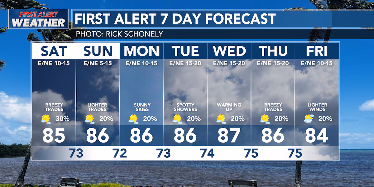
First Alert Forecast: Slightly weaker trade winds expected this weekend
HONOLULU (HawaiiNewsNow) – High pressure to the north of the island chain will continue to weaken throughout Saturday and Sunday. This will lead to slightly weaker trade winds throughout the weekend.
Read more ‘Divine Disruption’: Religion meets pop culture in new Honolulu Museum of Art exhibit
Showers will be mostly focused over windward areas throughout Saturday. Pop-up sea breeze showers are possible on the afternoons of Sunday and Monday. Expect trade winds to strengthen during the middle of next week.
A HIGH SURF ADVISORY is in effect for south-facing shores until Sunday at 6 PM. Waves on south-facing shores could reach heights of 8 to 12 feet. A reinforcing south swell is expected during the beginning of next week, which could extend the advisory further in time.
The first tropical cyclone of the 2026 hurricane season could form over the next week in the eastern Pacific, potentially becoming Tropical Storm or Hurricane Amanda.
Read more Coast Guard assists 20 adults, 1 child aboard disabled vessel offshore Maui
The forecasters have given the disturbance an 80% chance of formation over the next week and a zero chance of development over the next two days.
This storm is currently modeled to fall apart far away from the island chain, but it serves as a reminder that hurricane season is only beginning. Take time now to review your emergency plan and gather supplies in case of a landfall.
View the latest weather conditions here.
Download the HNN Weather app from the Apple App Store or Google Play for the latest updates from your First Alert Weather Team: chief meteorologist Jennifer Robbins, meteorologist Drew Davis, and weather anchors Guy Hagi, Ben Gutierrez, and Billy V.
Read more Dredging project at Lahaina Small Boat Harbor to start Monday, parking impacted


Post Comment