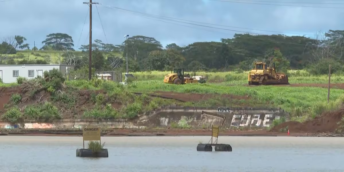
State releases Wahiawa Dam water to lower flood risk ahead of Tropical Storm Moke
HONOLULU (HawaiiNewsNow) – State emergency officials are urging residents downstream of the Wahiawa Dam to prepare for potential evacuations as Tropical Storm Moke approaches.
Read more First Alert Forecast: Moke’s outer bands will impact the Big Island of Hawaii initially this weekend
The Hawaii Emergency Management Agency (HIEMA), state Agribusiness Development Corporation (ADC), and the Department of Land and Natural Resources (DLNR) are actively monitoring the dam and releasing water to mitigate flood risks.
“Safety is our top priority and understanding how to prepare for possible evacuations is critical,” said HIEMA Administrator David Lopez.
Status of Wahiawa Dam
As of Friday morning, the reservoir’s water level was at 77.5 feet, below its 90-foot operating limit.
Since last week, dam owner ADC has been discharging water at the maximum safe rate.
The contractor for the Wahiawa Dam Rehabilitation Project, Goodfellow Bros. LLC, has begun installing an Aquadam bladder to raise the height of the dam embankment by 1.5 to 2 feet. This will effectively increase the dam’s spillway capacity and help to prevent water from overtopping.
“Remember, the higher you get up into that reservoir, the much larger the volume is,” Gov. Josh Green said Thursday. “It ends up being like billions of gallons as you get higher and higher. So for it to rise even further, it can take on a lot of water.”
Board of Land and Natural Resources Chair Ryan Kanaka‘ole said, “We want everyone to know that our teams have been working tirelessly for the past several weeks with dam owners and state and county agencies involved in emergency response. DLNR will continue to issue critical information during the storm.”
Alert levels
Based on multiple safety factors and the anticipated time required for emergency responders and the public to safely evacuate the areas surrounding Waialua and Haleiwa, the ADC has established several elevation triggers in its Emergency Action Plan (EAP) to notify Honolulu Department of Emergency Management:
“There’s an electronic measuring device that you can actually access off of your phone or off your computer so the residents can monitor that also,” Maj. Gen. Stephen Logan, Hawaii adjutant general, said Thursday.
Maj. Gen. Logan said a high-water vehicle team will also be stationed at the dam.
Read more HIEMA to request federal disaster declaration after Lala
“They’ll have a communicative device to be able to report that back to both my own joint operations center and Administrator Lopez’s Emergency Operations Center, and we’re doing all this in close concert with the City and County of Honolulu,” he explained.
The County DEM will determine when warnings should be issued, officials said. Officials noted that flash flood warnings issued by the National Weather Service may or may not be related to the ADC’s notifications.
Possible flooding unrelated to the dam
Low-lying areas from Waialua to Haleiwa, including Otake Camp, are situated in high-risk flood zones. These areas are prone to severe flooding during heavy rains as runoff flows down the north and northeast flanks of the Waianae mountain range and the Mokuleia Forest Reserve on its way to the ocean.
State officials warn residents that local flood risks in these areas are not solely caused by discharges from the reservoir. Residents can confirm their neighborhood’s flood risk using the Hawaii Flood Hazard Assessment Tool.
How to prepare
Evacuation Zones: Residents in low-lying areas should familiarize themselves with designated evacuation routes. If you feel threatened, consider self-evacuating to a safer location. If authorities issue an evacuation order, comply promptly.
Dam Evacuation Maps: To see if you are located in a dam evacuation inundation zone, use the Oahu Dam Evacuation Planning Tool.
Communication: Keep your cell phones fully charged and have battery backups ready. In addition to the National Weather Service and HNLAlert, download Hawaii News Now’s weather and news apps for live storm updates.
Preparation Tips: Build an emergency kit with water, non-perishable food, first-aid supplies, essential medications, flashlights, batteries, and important documents. Plan for your pets’ needs, keep your vehicle fueled, and be prepared to evacuate on foot if necessary.
“As we brace for the impending storm, I want to emphasize the importance of preparedness and community resilience,” said Lopez. “Local, state and federal officials are working diligently to ensure safety measures are in place, but we also need the cooperation of every resident. Please take this opportunity to prepare your homes and families, stay informed and look out for one another. Let’s navigate through this storm safely.”
For more information on disaster preparedness and to find your designated evacuation zones visit, Hawaii Emergency Management Agency website.
Read more Six-day Waikiki condo outage prompts storm warnings for other high-rises




Post Comment