First Alert Forecast: It’s All About Fausto
HONOLULU (HawaiiNewsNow) – Trade winds are sticking around and will continue to strengthen through the rest of the week, bringing that familiar summer weather pattern of passing windward and mauka showers.
Read more Woman identified in deadly head-on crash on Highway 11 in Volcano
We started the morning with a few more showers over Kauaʻi and Oʻahu, but those will gradually taper off this afternoon, leading to brighter skies for many leeward communities. As we head into Thursday and Friday, expect breezy to locally strong trade winds. That means a cooler feel, especially in the usual windy spots, along with rougher ocean conditions and increasing surf along east-facing shores.
South shore surf remains elevated thanks to a series of long-period swells. Another larger swell is arriving now and is expected to peak late Thursday into Friday, bringing advisory-level surf with some locations potentially approaching warning levels. If you’re heading to the beach, use extra caution as stronger currents and larger waves arrive.
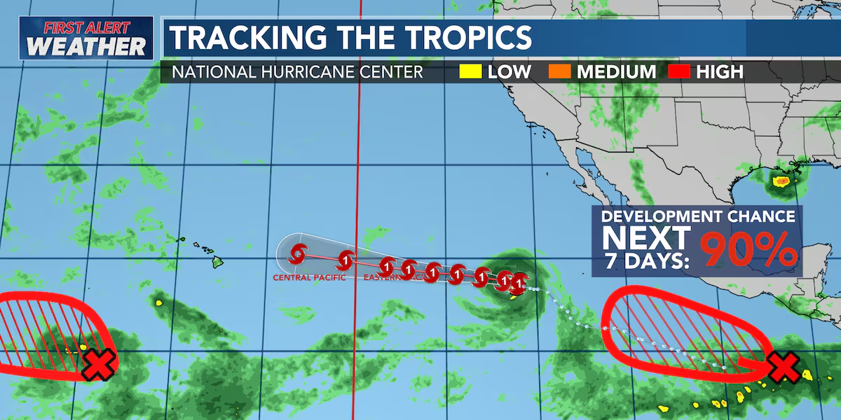
Looking ahead to early next week, we’re continuing to keep a close eye on Hurricane Fausto. Hurricane Fausto continues to battle dry air. The National Hurricane Center says the storm still has sustained winds of 80 mph (70 knots), but dry air has been disrupting the hurricane’s core and giving it a ragged appearance. Fausto could strengthen a little over the next day or two, but only modestly. After that, cooler ocean waters and increasing wind shear should begin a steady weakening trend, with the system expected to drop below hurricane strength by the end of the weekend.
Read more Belatti responds after Gov. Green questions her campaign message
For Hawaiʻi, we’re continuing to watch the forecast closely. The latest National Hurricane Center track keeps Fausto moving west to west-northwest while strengthening high pressure to the north steers it toward the Central Pacific. There is still noticeable uncertainty in exactly where the storm will track by early to mid next week, and even small shifts north or south could make a difference in our weather, winds, surf, and marine conditions. At this point, it’s too early to determine specific impacts, but confidence is increasing that Fausto will be in a weakening phase as it nears the Central Pacific.
We’ll continue tracking every update and let you know if the forecast changes. Have a great Wednesday, and we’ll keep you posted as we learn more.
View the latest weather conditions here.
Download the HNN Weather app from the Apple App Store or Google Play for the latest updates from your First Alert Weather Team: chief meteorologist Jennifer Robbins, meteorologist Drew Davis, and weather anchors Guy Hagi, Ben Gutierrez, and Billy V.
Read more Gov. Green, four mayors bring laughs to final day of Native Hawaiian Convention





Post Comment