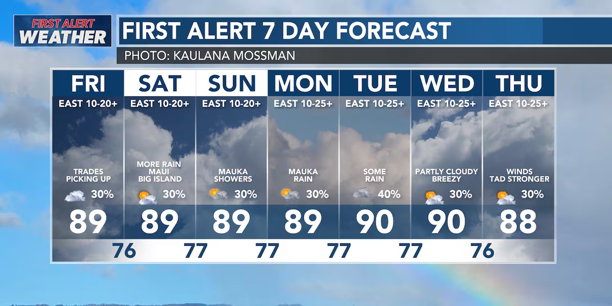
First Alert Forecast: Weekend Looks Windy
HONOLULU (HawaiiNewsNow) – Light to moderate trade winds continue today, with a few passing showers favoring windward and mauka communities, especially during the overnight and early morning hours.
Read more Maui security guard beaten to death; champion swimmer charged with murder
Radar this morning showed a few more showers than expected near Maui County and Oahu, so rain chances have been nudged upward slightly for today, but most areas will still see plenty of dry weather.
The bigger change arrives Friday as high pressure strengthens north of the islands. That will tighten the pressure gradient, bringing a return to breezy trade winds heading into the weekend.
Looking ahead, we’re keeping a close eye on a pocket of tropical moisture expected to move in from the east beginning Saturday afternoon. The greatest impacts are expected across the Big Island and Maui County through Monday, where deeper moisture and a weakening inversion could allow for periods of heavier showers, particularly along windward slopes. Some of the wettest windward locations could pick up a few inches of rain.
Oahu and Kauai are expected to remain on the western edge of this moisture, so while a few showers are possible, widespread heavy rain looks less likely at this time.
Read more Hawaii election officials urge last-minute votes as primary turnout lags
By Tuesday, the tropical moisture shifts away, allowing Hawaii to settle back into a more typical summer trade wind pattern with moderate trades and mainly nighttime and early morning windward showers.
Marine conditions also become more active this weekend. Trade winds strengthen, creating rougher conditions for east-facing waters, while a series of south swells arrives beginning Saturday. Surf along south and west shores will steadily build through the weekend and could approach High Surf Advisory levels by the middle of next week. East shore surf also increases with the strengthening trades, while north shore surf remains very small.
Overall, expect a classic summer pattern over the next few days: breezier trades, mostly dry leeward weather, and the best chance for meaningful rainfall focused on windward Big Island and Maui County from late Saturday into Monday.
View the latest weather conditions here.
Download the HNN Weather app from the Apple App Store or Google Play for the latest updates from your First Alert Weather Team: chief meteorologist Jennifer Robbins, meteorologist Drew Davis, and weather anchors Guy Hagi, Ben Gutierrez, and Billy V.
Read more HPD doubles Crisis Intervention Team, expands MH-3 program across Oahu





Post Comment