First Alert Forecast: Waiting for Lala
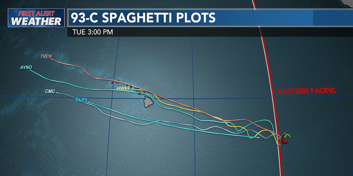
HONOLULU (HawaiiNewsNow) – While the National Hurricane Center is confident a tropical cyclone is forming to the east of us; it is looking more likely by Wednesday it will become more organized and finally get a name and track. If it’s in the East Pacific, the name will be Hernan. If it’s in the Central Pacific, it will be Lala. The dividing line is 140W.
Read more South Kihei Road reopens ahead of schedule following Kona low repairs
Regardless of name, the system will very likely bring strong winds, heavy rain, and big surf to the island chain this weekend. It’s too soon to know just how wet and windy it will be. But most computer models have the storm reaching Hawaii Island sometime late Friday or Saturday and moving across the island chain from east to west through Sunday with a big range in rain from a few inches to up to 16+ inches on Hawaii Island.
Now is a good time to get your hurricane kit together. For a helpful checklist go to hawaiinewsnow.com/hurricanechecklist.
We will keep you updated as the storm organizes and strengthens. Stay with us, your First Alert Weather Station.
Weather leading up to the weekend should be very nice. Expect breezy trade winds. Showers will be few and mainly windward and mauka. Skies will be sunny with afternoon highs in the upper 80s. Hawaii weather remains mostly dry through Friday, with breezy trade winds and a few passing showers favoring windward and mauka areas. Trades are expected to strengthen Thursday into Friday, and fire weather concerns will increase as conditions become drier and winds pick up.
Read more Blessing held for new Sand Island Wastewater Treatment Plant facility
Tropical wave 93C, is currently more than 1,000 miles east-southeast of Hawaii and has a 90% chance of developing over the next 48 hours. While confidence is increasing that Hawaii could see tropical cyclone impacts this weekend, the exact track, strength and severity remain uncertain because the system has not fully formed yet.
Surf is a bit elevated on south and west shores. A new long-period swell is expected to push south shores to advisory levels late Wednesday into Thursday. The east shores continue to be a bit rough due to the breezy trade winds. The tropical system headed our way could potentially kick up east shore surf even more, perhaps approaching warning levels. Warning-level surf of 15 feet or higher is possible. Now is the time to stay informed and prepare.
Check on loved ones, neighbors and our kupuna, and make sure you have what you need before the weekend. I’ll continue tracking 93C closely and will keep you updated as we learn more. Again, potential impacts could include strong and gusty winds, heavy rainfall and flash flooding, and a significant increase in east to southeast shore surf.
View the latest weather conditions here.
Download the HNN Weather app from the Apple App Store or Google Play for the latest updates from your First Alert Weather Team: chief meteorologist Jennifer Robbins, weather anchors Dan Cooke, Guy Hagi, Ben Gutierrez, and Billy V.
Read more ‘Where there’s smoke, there’s fire’: Maui police lieutenant denied bail in federal bribery case





Post Comment