First Alert Forecast: Strong winds possible statewide as Nolo passes to the south
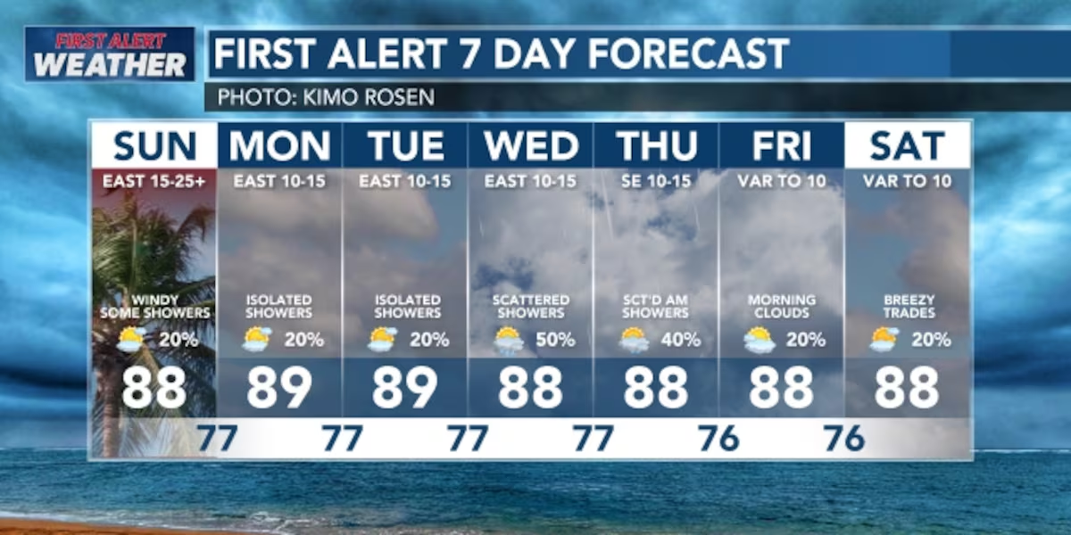
HONOLULU (HawaiiNewsNow) – Trade winds will be strong and gusty Sunday as Hurricane Nolo moves westward, well to the south of the islands. Conditions should be a bit drier as Nolo’s tropical moisture moves further away from the state.
Read more ‘Bows fall to Wyoming on the road, 27-10
More stable weather is being ushered in by high pressure to the north, which is also pushing Nolo westward. However, the interaction between the high and the hurricane is resulting in the gusty trades.
A Wind Advisory has been expanded to all islands, and a High Wind Warning is up for portions of Maui County and Hawaii Island. Winds should ease by Sunday night.
Looking ahead, a band of moisture trailing Nolo could move over the islands midweek, which could lead to increased showers, especially for Kauai and Oahu, around Wednesday and Thursday.
Read more Hurricane Nolo brings strong winds and rough surf to Oahu
View the latest weather conditions here.
Large waves are still being generated by Nolo. A High Surf Warning remains posted until 6 a.m. Sunday for the southeast shores of Hawaii Island. A High Surf Advisory is in effect until 6 p.m. Sunday for east shores of Kauai, Oahu, Molokai, Maui and Hawaii Island. The high waves will diminish late Sunday.
Surf will increase along south shores as Nolo treks westward. This will combine with an incoming moderate south-southwest swell, and a high surf advisory may be issued for south shores. North and west shores could see a bump from a small, long-period northwest swell.
For mariners, a Gale Warning is posted for all nearshore coastal waters.
Download the HNN Weather app from the Apple App Store or Google Play for the latest updates from your First Alert Weather Team: chief meteorologist Jennifer Robbins and weather anchors Guy Hagi, Dan Cooke, Ben Gutierrez, and Billy V.
Read more Evacuation order issued for Olowalu Village due to brush fire







Post Comment