Tropical Storm Nolo strengthens as it makes a northward turn
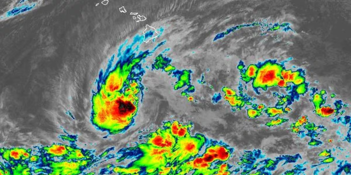
HONOLULU (HawaiiNewsNow) – Tropical Storm Nolo has increased in strength and has started to turn northward on a track that will bring it close to Hawaii Island Friday into Saturday.
Read more DLNR asks drivers to slow down after 3 nene killed on Molokai
A Hurricane Watch remains in effect for Hawaii County. This means that hurricane conditions are possible within the next 48 hours.
The National Hurricane Center said at 11 p.m. Wednesday, Nolo was centered about 285 miles south of South Point, or 460 miles south-southeast of Honolulu. It was moving slowly to the north at 2 miles per hour.
Nolo’s maximum sustained winds have increased to 50 miles per hour. Tropical storm force winds extend outward 80 miles from the center.
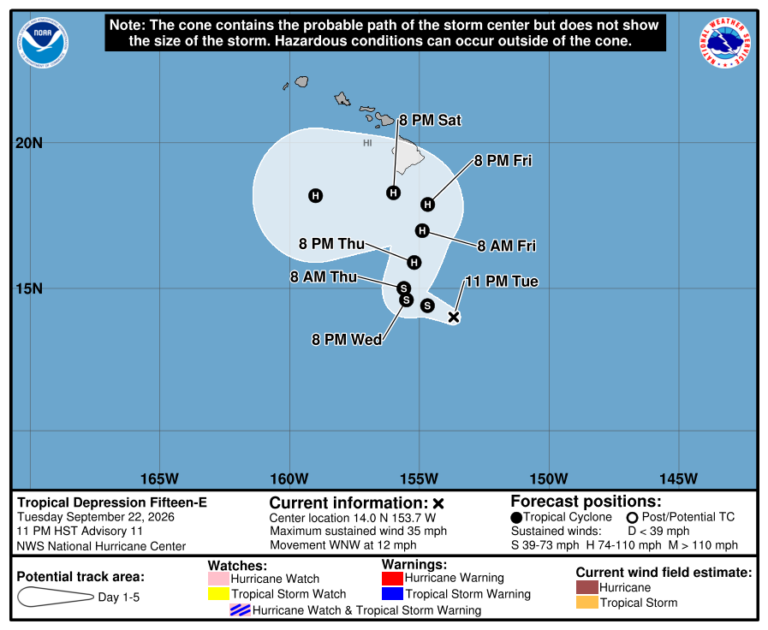
The tropical storm is moving into an area with very warm sea surface temperatures and abundant moisture. Some wind shear will tamp down is rate of strengthening, but the shear is expected to relax which will allow Nolo to strengthen rapidly. It is forecast to become a hurricane Thursday and then strengthen further into a major hurricane this weekend.
Nolo’s is expected to move slowly to the north to northeast, which will take it close to Hawaii Island Friday into Saturday, potentially as a major hurricane. It will then make a sharp turn to the west on Saturday. However, a high level of uncertainty remains in the forecast, and Nolo could make a closer approach to Hawaii Island, which would substantially increase the threat of damaging wind.
Potential threats
WIND: Hurricane conditions are possible in the watch area starting as early as Friday night.
Hurricane conditions with winds of 74 miles per hour or stronger are possible on Hawaii Island. Residents and visitors should prepare for life-threatening winds of category 1 or 2 hurricane force, or 74 to 100 miles per hour.
RAIN: Tropical Storm Nolo will produce rainfall totals of 15 to 20 inches across Hawaii Island with maximum amounts of 35 inches. This rainfall may produce catastrophic life-threatening flooding and mudslides, especially in areas of steep terrain. This includes areas on Hawaii Island that were already heavily damaged by flooding from Hurricane Lala in August.
Read more Still recovering from March storms, Maui golf course prepares for Tropical Storm Nolo
The island of Maui can expect rainfall totals of 5 to 10 inches with maximum amounts of 20 inches. Life-threatening flooding and mudslides possible across Maui, especially in areas of high terrain.
Across the rest of the state, rainfall amounts of 1 to 3 inches with maximum totals of 6 inches will be possible and could cause localized flooding.
STORM SURGE: The combination of a dangerous storm surge and the tide will cause normally dry areas near the coast to be flooded by rising waters moving inland from the shoreline. The water could reach the following heights above ground somewhere in the indicated areas if the peak surge occurs at the time of high tide: Hawaii County 1 to 3 ft.
Weather Alerts
A Hurricane Watch has been issued for Hawaii County.
A Flood Watch has been issued for the islands of Hawaii and Maui County from noon Wednesday through 6 p.m. Saturday, according to the National Weather Service forecast office in Honolulu.
Prepare now
The National Weather Service and your First Alert Weather Team say you should have effort to protect life and property underway now and to prepare for considerable wind damage.
Preparations should also be underway for heavy rainfall and catastrophic flash flooding.
Related posts
View the latest weather conditions here.
Download the HNN Weather app from the Apple App Store or Google Play for the latest updates from your First Alert Weather Team: chief meteorologist Jennifer Robbins and weather anchors Guy Hagi, Dan Cooke, Ben Gutierrez, and Billy V.
Read more Man dies after losing control of vehicle, crashing into tree in Lahaina







Post Comment