First Alert Forecast: Tracking “Norbert” and periods of heavy rain
HONOLULU (HawaiiNewsNow) – A Flood Watch is up for all of the islands as we track the remnants of Norbert that will bring us periods of heavy rain to the islands especially windward and mauka.
Read more Volunteers needed on Kauai as Red Cross shifts to long-term hurricane recovery
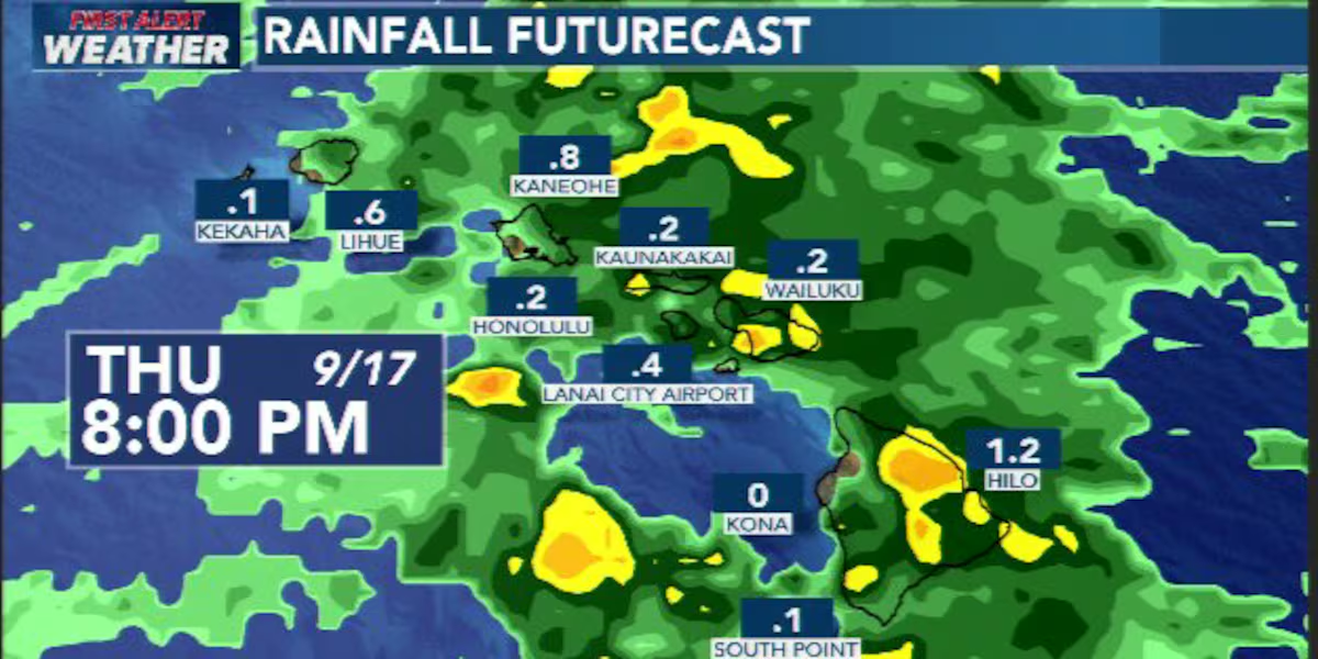
Breezy trade winds will continue through the middle of next week, with a wetter pattern developing Thursday into Friday.
An upper-level trough will move in from the east, pulling in moisture left behind from the remnants of Norbert. That moisture will spread across the islands from east to west, bringing more widespread showers, including some locally heavy rain. The biggest concern will be for windward and mauka areas, where the combination of deep tropical moisture and instability could also trigger isolated thunderstorms and flash flooding.
The Big Island has the highest chance of thunderstorms Thursday afternoon, but heavier showers could pop up elsewhere. And because some areas are still fairly saturated from recent heavy rain, it won’t take much additional rainfall to cause flooding in the more vulnerable spots.
Things should gradually dry out from east to west late Friday into the weekend as the trough moves away. But we may not stay dry for long. Moisture from the remnants of Tropical Depression 15-E could move in around Tuesday and Wednesday of next week, bringing another increase in trade showers. Right now, the upper-level pattern looks less supportive of widespread heavy rain, so there’s more uncertainty with that next round.
For today, trades will pick up to breezy levels as the trough approaches. Clouds and showers will increase tonight, first across the eastern islands and then spreading westward.
Read more Former Lahainaluna principal wanted on felony charges
Windward and mountain areas could see more widespread cloudy, wet conditions, with some periods of reduced visibility.
On the marine side, northeast trade winds will strengthen today, with the strongest winds around the Big Island and Maui County. A Small Craft Advisory remains in effect for those typically windier waters through tonight. The added moisture and instability could also produce thunderstorms over the offshore waters through Saturday, bringing heavy rain and sudden gusty winds.
Surf will be picking up as well. South-southwest swells will continue building through the week, with surf potentially reaching High Surf Advisory levels by the weekend as the swell shifts more southerly. East-facing shores will also see a bump as the trades strengthen and a small east swell arrives. North shore surf will remain tiny.
View the latest weather conditions here.
Download the HNN Weather app from the Apple App Store or Google Play for the latest updates from your First Alert Weather Team: chief meteorologist Jennifer Robbins and weather anchors Guy Hagi, Dan Cooke, Ben Gutierrez, and Billy V.
Read more Maui native Parker Welck rises in professional disc golf




Post Comment