First Alert Forecast: Wet Weather On the Way
HONOLULU (HawaiiNewsNow) – It’s been a wet day so far for windward Oahu and East Maui. There’s even heavier showers just off shore and moving west. With a little luck they should stay away.
Read more New vents open at Kilauea summit as eruptive activity continues
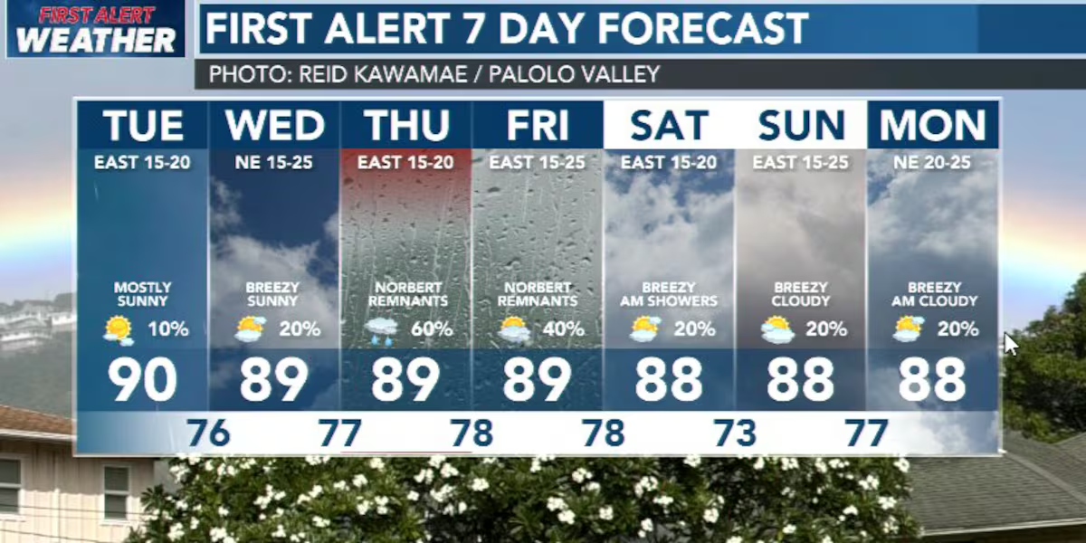
Our weather eyes are mainly focused about 750 miles upstream in the trade wind flow. That’s where the remnants of former Hurricane Norbert are gathered and heading this way. It’s not Norbert wind or surf that’s concerning. It’s the moisture.
Windward and mauka neighborhoods could see the Norbert rainfall as early as Wednesday evening. Thursday appears to be the day with the most showers rolling in… and leeward areas will get their share. The showers could be heavy at times and there’s a mention of thunderstorms in the forecast for Friday. It you live or work in a place that’s susceptible to flooding, be on alert.
We should be in the (mostly) clear Saturday with some sunshine and passing showers. Sunday looks cloudy and a bit wet. Then Monday/Tuesday is when the moisture from Tropical Depression 15-E comes to town. It will be similar to the Norbert experience… a couple days of wet windward and mauka weather. Perhaps some isolated heavy showers.
Read more 2 boaters injured after vessel hits submerged object near Molokini
Surf is coming up on the south shore today. There’s a second south due sometime Friday.
View the latest weather conditions here.
Download the HNN Weather app from the Apple App Store or Google Play for the latest updates from your First Alert Weather Team: chief meteorologist Jennifer Robbins and weather anchors Guy Hagi, Dan Cooke, Ben Gutierrez, and Billy V.
Read more Spotlight Now: Kauai mayoral candidates forum on storm recovery, housing crisis




Post Comment