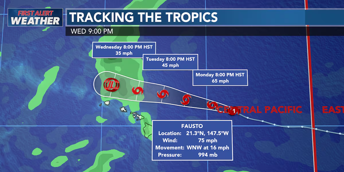
First Alert Forecast: Fausto Weakens to Tropical Storm
HONOLULU (HawaiiNewsNow) – Former Hurricane Fausto is now a Tropical Storm and continues to weaken as it approaches Hawaii.
Read more Hokulea original crew reunites for 50th anniversary of maiden voyage to Tahiti
The weather models are now in closer agreement showing Fausto passing north of the islands Tuesday night into Wednesday. While the overall forecast is becoming more favorable, this is not a storm to ignore.
The strongest winds and heaviest rain are still expected to stay north of the state, but even small changes in the track or how quickly Fausto weakens could affect impacts across the islands. That’s why the First Alert Weather Team will continue to monitor it around the clock.
For most of Hawaii, expect moderate to breezy trade winds today along with passing windward and mauka showers. As moisture from Fausto moves in, showers will become more numerous tonight into Tuesday, especially for windward communities. Most areas will see light rainfall, but some higher elevations could pick up around a half inch to an inch.
It will also feel noticeably more humid Tuesday and Wednesday. The biggest story continues to be the surf.
Read more Hawaii Career Expo returns to Blaisdell Center
A High Surf Warning is now in effect for east-facing shores through Wednesday. Surf is building faster than expected and could reach warning levels, creating dangerous ocean conditions with powerful waves, strong currents, and rough shore break. Minor coastal flooding is also possible in vulnerable low-lying areas, including some roads, boat ramps, and harbors exposed to the large east swell. If you’re heading to the beach, use extreme caution and stay well back from the water’s edge.
Even after Fausto moves away, the surf won’t stay down for long. A brief lull is expected late Wednesday into Thursday, but another round of large east swell is forecast to arrive Friday into the weekend. This one is being generated by Major Hurricane Genevieve, currently spinning over the eastern Pacific.
As that long-period swell combines with strengthening trade wind waves, east-facing shores are expected to become rough once again heading into the weekend. South shore surf will remain elevated today before gradually easing through the week, while north shores could see a small bump in surf as Fausto passes north of the islands before returning to typical summer conditions.
View the latest weather conditions here.
Download the HNN Weather app from the Apple App Store or Google Play for the latest updates from your First Alert Weather Team: chief meteorologist Jennifer Robbins, meteorologist Drew Davis, and weather anchors Guy Hagi, Ben Gutierrez, and Billy V.
Read more UHERO study reveals progress, persistent challenges for Maui wildfire survivors





Post Comment