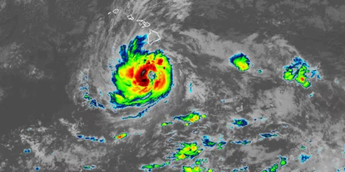
Hurricane Nolo remains stationary just south of Hawaii Island
HONOLULU (HawaiiNewsNow) – Hurricane Nolo remains stationary just south of Hawaii Island, but is forecast to turn westward Saturday into Sunday.
Read more FBI urges victims to come forward in Moanalua wrestling coach case
While Nolo’s center is remaining south of the main Hawaiian islands, significant flash flooding remains possible for Hawaii Island, along with damaging waves and storm surges.
The National Hurricane Center said at 8 p.m. Friday, Nolo’s maximum sustained winds were holding at 105 miles per hour, making it a category 2 hurricane.
Hurricane force winds extend up to 45 miles from the center, while tropical storm force winds extend outward up to 140 miles.
Nolo was centered about 150 miles south of South Point, or 350 miles south-southeast of Honolulu. The hurricane is currently stationary.
Nolo is forecast to decrease its forward speed through Friday night. A turn toward the west-northwest and west with an increase in forward speed is forecast Saturday and Sunday. On the forecast track, the center of Nolo will remain well south of the main Hawaiian Islands.
Nolo will then rapidly intensify into a major category 3 hurricane by this weekend.
A Tropical Storm Warning has been issued for Hawaii County as Tropical Storm Nolo continues to strengthen to the south of Hawaii Island.
A Tropical Storm Watch has also been issued for the islands of Maui County. A Hurricane Watch remains in effect for Hawaii County. This means that hurricane conditions are possible within the next 48 hours.
The tropical storm warning means that tropical storm conditions are expected in the warning area within 36 hours, while the tropical storm watch means tropical storm conditions are possible within the next 48 hours.
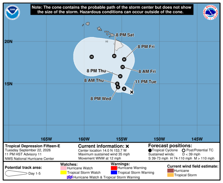
The hurricane is in an area with very warm sea surface temperatures and abundant moisture which will cause rapid intensification.
Potential threats
WIND: Tropical storm conditions are occurring in portions of the warning area in areas of steep terrain. Hurricane conditions are possible by early Saturday.
Tropical storm conditions are possible in the tropical storm watch area beginning on Saturday. Gusts to tropical storm force are occurring in Maui County in areas of steep terrain.
Read more HECO crews standing by as Hurricane Nolo marches toward islands
Regardless of the exact track of Nolo, strong and gusty winds are possible for all of the Hawaiian Islands through the weekend.
RAIN: For the eastern and southern portions of Hawaii Island, Nolo will produce rainfall totals of 8 to 12 inches with maximum amounts of 16 inches. This rainfall could produce significant, life-threatening flooding and mudslides, especially in areas of steep terrain.
For the western portions of Hawaii Island, rainfall totals of 1 to 3 inches with maximum amounts of 6 inches are expected.
For eastern Maui, rainfall totals of 4 to 6 inches with maximum amounts of 8 inches are expected. Life-threatening flooding and mudslides are possible, especially in areas of high terrain.
Across the remainder of the Hawaiian Islands, maximum rainfalltotals of 1 to 2 inches are expected.
STORM SURGE: The combination of a dangerous storm surge and the tide will cause normally dry areas near the coast to be flooded by rising waters moving inland from the shoreline. The water could reach the following heights above ground somewhere in the indicated areas if the peak surge occurs at the time of high tide: Hawaii County 1 to 3 ft.
Weather Alerts
A Tropical Storm Warning is in effect for Hawaii County.
A Hurricane Watch is in effect for Hawaii County.
A Tropical Storm Watch has been issued for Maui County, including the islands of Maui, Molokai, Lanai and Kahoolawe.
A Flood Watch remains in effect for the islands of Hawaii and Maui County through 6 p.m. Saturday.
A High Surf Advisory has been issued for the east shores of Molokai and Maui and the east and southeast shores of Hawaii Island.
A Wind Advisory will take effect at 6 a.m. Saturday until 6 p.m. Sunday for Niihau, Kauai and Oahu. East winds of 25 to 35 miles per hour with gusts near 55 miles per hour will be possible.
Prepare now
The National Hurricane Center says now is the time to complete all preparations to protect life and property in accordance with your emergency plan:
Related posts
View the latest weather conditions here.
Download the HNN Weather app from the Apple App Store or Google Play for the latest updates from your First Alert Weather Team: chief meteorologist Jennifer Robbins and weather anchors Guy Hagi, Dan Cooke, Ben Gutierrez, and Billy V.
Read more Economists predict lasting damage to tourism from recent storms







Post Comment