First Alert Forecast: Tracking potential rain from the remnants of Norbert
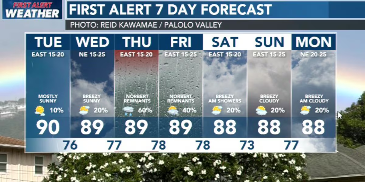
HONOLULU (HawaiiNewsNow) – The trade winds are getting stronger, and we’ll feel that change starting Wednesday. Moderate trades will become breezy at times and continue through the weekend. At the same time, moisture will be increasing across the islands from east to west, bringing more showers, especially to windward and mauka areas.
Read more Beloved Hawaii Island book shack sits in ruins with its next chapter uncertain
The bigger weather story develops Thursday into Friday. Moisture left behind by Norbert will move across the state, and an upper-level disturbance moving overhead will add instability. That combination could produce some locally heavy rain, particularly for windward areas, with the potential for flooding.
A Flood Watch could be issued as early as Wednesday, depending on how the forecast comes together.
We’re already seeing showers mainly along windward and mauka areas, with some moderate to locally heavy showers just upstream of Oʻahu and Kauaʻi.
Those showers will move in with the northeast trades, so expect passing showers to become more frequent tonight and into Wednesday as the atmosphere becomes increasingly saturated.
Read more Hirono presses FBI Director Kash Patel during Senate hearing
By late Friday and into the weekend, drier air should filter back in, although the trades will remain moderate to breezy. Surf will also be building along south-facing shores through the week, with larger south-southwest swells arriving Friday into the weekend.
East shore surf will gradually increase as the trades strengthen, while north shore surf stays tiny.
And we may not be done with the moisture next week. Another boost of tropical moisture from the remnants of Tropical Depression 15-E could move toward Hawaiʻi Monday or Tuesday. There’s still a fair amount of uncertainty on how much moisture reaches the islands, with the GFS showing a wetter scenario than the ECMWF, so we’ll have a better idea by Friday.
View the latest weather conditions here.
Download the HNN Weather app from the Apple App Store or Google Play for the latest updates from your First Alert Weather Team: chief meteorologist Jennifer Robbins and weather anchors Guy Hagi, Dan Cooke, Ben Gutierrez, and Billy V.






Post Comment